Survey errors occur on various jobs but become particularly costly on major construction projects. Accurate measurements are essential, starting from the engineering stages.
Even small mistakes from global navigation satellite system (GNSS) problems can raise costs. This can happen because of rework or wasted materials. These mistakes can also create complicated legal issues for the construction even after the workers complete the job.
Trimble has many GNSS products to help you feel more confident when surveying. They have decades of experience in the construction surveying market. If you need high accuracy in the pre-engineering stage or want to save on a tight budget, we can help. We’ll equip your firm with a clear framework for choosing the optimal Trimble GNSS solution.
Understanding GNSS Technology
You probably know about the Global Positioning System (GPS). The term GNSS includes GPS and all other satellite navigation systems used worldwide. Other systems include Russia’s GLONASS, Europe’s Galileo, China’s BeiDou, and regional systems like Japan’s QZSS and India’s IRNSS.
No matter the satellite system, GNSS receivers connect to it. They turn the signals into accurate position readings.
By using triangulation and similar calculations, we can make other surveying methods more accurate. This also helps fix small errors that can be added during a project. The GNSS receiver can complete this task itself or in combination with a base station that needs correction.

Key Selection Factors
Four primary selection factors exist when choosing a GNSS receiver that best aligns with your needs.
1. Application Requirements
These receivers are used across the many branches of surveying work. They’re essential for establishing accurate property lines in cadastral surveying of land boundaries and settling legal disputes.
GNSS receivers must work offline and be exceptionally durable for surveying tasks like mining and landscape planning. Machine-control applications are incredibly demanding. They need highly accurate GNSS survey information, which helps direct heavy equipment for land clearing, grading, and other construction tasks.
2. Accuracy Needs
Each type of surveying work requires a different level of accuracy. There is no need to spend more on a GNSS receiver that offers accuracy you don’t need.
Construction work often cannot proceed because of important engineering design questions and land boundary disputes. You need accurate measurements in centimeters or even millimeters. Projects like landscaping and roadworks may only require sub-meter accuracy from an affordable receiver model.
3. Environmental Conditions
Congested work sites, especially those used for construction, make GNSS for construction challenging without the right receivers. Multipath risks from reflected signals bouncing off obstacles like tall buildings complicate surveying in urban environments.
This problem gets worse because of urban canyons. These are areas where satellites have low connectivity, and tall buildings and other structures create canyon-like spaces.
In more rural areas, tree lines, wooded areas, and foliage also interfere with a strong GNSS signal. Civil engineering projects like power plants, dams, and roads depend on Trimble equipment, which offers better durability and damage resistance. Connectivity options ensure good results, no matter what urban or rural environmental challenges affect your project.
4. Budget Constraints
There is no need to invest in the top-of-the-line GNSS equipment if you only need a simpler model. Finding the right balance is important. You need to consider advanced features and total equipment cost. This will help you choose the best damage resistance, accuracy, and connectivity options.
Business Benefits of Upgrading
Your surveying or engineering business can access several potential benefits by upgrading to advanced GNSS receivers, including:
- Work quality: Sub-centimeter precision lowers the need to rework important property and engineering surveys, a significant cost factor for many construction projects.
- Speed: Faster real-Time Kinematic (RTK) convergence and rapid data capture reduce unnecessary wait times in the field
- Profit: Accurate and easy-to-use GNSS equipment can lower labor costs. This happens because it boosts productivity with smaller teams, leading to higher profits.

Top Trimble GNSS Models for Construction Firms
Construction firms can choose from a number of top Trimble GNSS models.
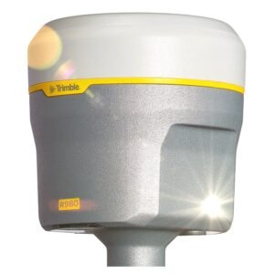
1. Trimble R980 ($10,900.00)
The Trimble R980 is a top GNSS receiver. People recognize it for its high-quality and scalable channels. This makes it ideal for heavy-civil control networks.

You can choose between a 450/900 MHz dual-band UHF radio or a 4G LTE Cellular modem. Both options offer advanced signal management and constant corrections.
The R980 has better connectivity features. It also includes a magnetically immune Inertial Measurement Unit (IMU) for tilt compensation. Plus, it has a tough military-grade design with an IP-67 rating.
Land surveyors who want high accuracy will like this model. It offers 9 GB of memory and a 12-month subscription to Trimble CenterPoint® RTX correction service, which has a 2-centimeter standard.
2. Trimble R12i
The Trimble R12i provides premium accuracy in challenging situations. It performs well in wooded areas, near treelines, tall buildings, and other congested sites.
This model’s Trimble xFill corrections reduce problems with poor connectivity and loss of access to RTK position services, helping reduce downtime in the field.
It provides continuous RTK and VRS coverage during correction outages. This is useful when there are radio and cellular black spots. Advanced tilt correction means it works in urban and rural environments where congestion prevents vertical sky access.
This model is great for roadwork. It meets the complex layout needs of civil and residential construction and is useful for cadastral surveying before construction starts.
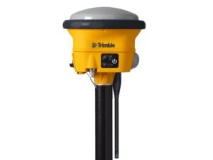
3. Trimble R780 ($9,800.00)
If you need a tough GNSS receiver to handle the field, consider the Trimble R780. It gives fast and high-quality RTK results, ideal for large infrastructure projects like dams, earthworks, and roadworks. Built-in radios and quick setup steps make this surveying equipment great for teams with less experience.

Pick the correct setup and features for your job. Discover how Trimble lets you add more functions as your needs change. Thanks to IMU-based tilt compensation, you can achieve high grades on QA/QC of executed work even on large site areas.
4. Trimble R2
This entry-tier model is perfect for expanding construction site planning options without such a significant investment. It provides simplicity and mobile-app pairing for smaller crews in a compact package. Yet it’s still quite durable, providing a rugged IP65 rating.
You can process your data using Trimble’s office software, like TerraFlex or the Business Center. This helps you create deliverables with less effort.
The R2 provides many geospatial applications with positioning accuracy from submeter to centimeter. This makes it an excellent choice for surveying mines, construction sites, roadwork, and finding buried cables and pipes. It is also helpful for cadastral services.
5. Trimble R580
Need ProPoint performance at an entry-level price*? The Trimble R580 is likely your best fit. It provides utility mapping and topographic survey features needed in urban and rural environments.
You can get precise corrections within 2 centimeters. Subscribe to the Trimble CenterPoint® RTX service for real-time updates. This service works through satellite or the internet.
You do not need a local base station or VRS network. The Trimble EVEREST Plus system improves multipath mitigation for cleaner signals.
*Consult your Trimble reseller for current pricing
Total Cost of Ownership (TCO) Considerations
Calculating your total cost of ownership (TCO) involves just a few distinct factors:
- Upfront Costs: The different levels of sub-meter accuracy and equipment durability greatly affect the total cost of ownership. Choose the right combination of receiver, accessories, and base station to avoid overspending if needed.
- Ongoing Expenses include RTK and RTX correction subscriptions, service plans, connected business software, and training support.
- Upgrading your GNSS receivers can help you earn a return on your investment (ROI). This can happen by reducing re-work requests for surveying. You will also benefit from faster site setups and lower labor costs. Additionally, you can increase your total billable hours.
- Potential Financing Options: Trimble and its resellers offer various financing options. If you need higher-grade equipment than you can afford right now, this may help.

Implementation & Best Practices
Even the best GNSS receivers can’t provide the ROI you expect unless you put them to their best use. Try these tips for implementation and receive the best practices.
Control Network Setup: Base Stations vs. CORS Access
Setting up a base station near your GNSS receivers will provide more accurate results. This is better than using Continuously Operating Reference Stations (CORS). These reference points can help set up survey control points for construction projects at no cost. However, small mistakes can cause bigger problems later on.
Daily QA Routines: Accuracy Checks, Calibration Logs
Establish daily QA routines for your receivers, including accuracy checks and full calibration logs. Check for any problems in these checks. This will help you avoid redoing the whole project because of one receiver or connection.
Operator Onboarding: Certification Paths and Refresher Training
Top-quality surveying equipment is only as useful as the operator’s skill. Invest in certification paths and refresher training directly from Trimble for the best results.
Maintenance Schedules: Firmware Updates and Battery Health
Battery health requires proper charging and discharging habits to prevent damage. Your crew must also limit shocks, drops, and exposure to extreme temperatures. Don’t forget to keep up with any necessary firmware updates to access the latest features and connectivity support.
Frequently Asked Questions
RTK vs. RTX: Which correction service suits my connectivity?
RTK services are only available where you can connect to a base station. You often need to set up multiple receivers. For this level of correction service in areas with low connectivity and high congestion, consider RTX subscriptions. These subscriptions provide accuracy through satellite or internet connections.
Tilt Compensation: How much time does it save per stakeout?
The time it takes can change based on the project and its challenges. However, tilt compensation can save hours on big projects with many contact points.
Leasing Options: Are financing plans available for small firms?
Trimble and its partners provide several financing options, some aimed at small and medium-sized surveying firms.
Model Upgrades: Can I trade in older units toward newer Trimble receivers?
Trimble partners routinely offer trade-in deals, allowing you to exchange your older equipment for credits towards new models. Contact your reseller to find out what’s available.
Power Management: What battery runtime can I expect on a full charge?
The runtime on these receivers can vary. It depends on the model, features in use, and outdoor temperatures. It can last from 3 hours to over 24 hours.
Next Steps Recap
If you still need more data to help align your project needs with the right GNSS features, we can help. Download the full spec sheet for each model and use that information to run your TCO model for each Trimble receiver option. If you still need more information to make the right decision, contact us at Harper Surveying to request an on-site demo today.
