

The Spectra Precision SP90m is a powerful, highly versatile, ultra-rugged, and reliable GNSS positioning solution for a wide variety of applications in real-time and post-processing. SP90m comes with a variety of integrated communications options, such as Bluetooth, WiFi, UHF radio, cellular modem, and two MSS L-band channels to receive Trimble RTX correction services.
The modular form factor of the SP90m allows for a maximum in flexibility on how the receiver can be used, such as base station, continuously operating reference station (CORS), RTK or Trimble RTX rover, on-board machine integration, vessels, etc. The ultra-rugged design of the aluminum receiver housing protects the investment, especially in tough field environments.
The state-of-the-art and patented Z-Blade GNSS-centric technology uses all available GNSS signals to deliver fast and reliable positions in real-time. Besides supporting all currently available and future planned GNSS satellite signals, the SP90m GNSS receiver allows the connection of two GNSS antennas for precise heading determination without the need for a secondary GNSS receiver.
With an ultra-rugged design, the Spectra Precision SP90M GNSS Receiver is a powerful, highly versatile, modular receiver designed for a wide array of real-time and post-processing applications. This professional-grade GNSS receiver offers a variety of integrated communication options such as RTCM-3 format, two MMS L-band channels, and built-in Bluetooth and Wifi for receiving Trimble RTX correction services. Featuring Spectra’s patented Z-Blade technology, the SP90M features 480 channels (GPS, GLONASS, GALILEO, BeiDou, QZSS, IRNSS, and SBAS).
With a 99.9% reliability, the Spectra Precision SP90m comes with an instant RTK initialization with a range of up to 24 miles. Plus, it includes a backup RTK and bridge for accurate positioning. This GNSS receiver supports rapid data processing with a recording interval of up to 999 seconds. For a more effective surveying operation, it has additional features like event marker input, PPS output, and Dual GNSS antenna inputs. It is also equipped with a 3.5G cellular modem that can be used for SMS, e-mail, and internet connectivity.
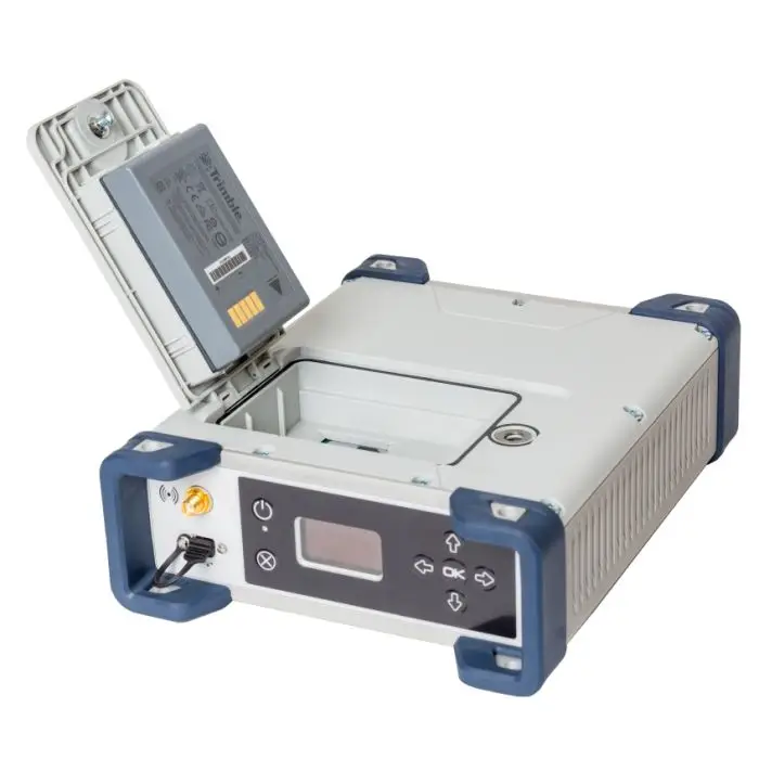
The Spectra Precision SP90m GNSS Receiver features an advanced OLED display, keyboard, and Web UI. It can also resist a drop of up to 3.3 feet and is dustproof and water-resistant (IP67). This Spectra GNSS receiver can easily store lots of information with its 8GB memory. As an extra feature, it boasts an anti-theft technology for the protection of the instrument.
Spectra Precision SP90m Features
- Reliable with an ultra-rugged design
- Highly versatile, modular receiver design
- RTCM-3 format
- 2 MMS L-band channels
- Built-in Bluetooth and Wifi communications
- Trimble RTX correction services
- 480 GNSS channels (GPS, GLONASS, GALILEO, BeiDou, QZSS, IRNSS, and SBAS)
- Z-Blade technology
- 3.5G cellular modem
- SMS, e-mail and internet connectivity
- 99.9% reliable
- Instant RTK initialization
- RTK range up to 24 miles (40 Km)
- Backup RTK and bridge
- Recording interval up to 999 seconds
- Event marker input
- ·PPS output
- Dual GNSS antenna inputs
- OLED display, keyboard, and WEB User Interface
- Drop-resistant up to 3.3 feet (1m)
- IP67 dustproof and water resistant
- 8GB internal memory
- Anti-theft technology
Spectra Precision SP90m specification
- Most versatile, modular receiver design
- Ultra-rugged design
- Patented Z-Blade technology
- 480-channel ASIC
- Dual GNSS antenna inputs
- Event marker input
- PPS output
- OLED display, keyboard, and Web UI
- Internal TRx UHF radio
- 3.5G cellular modem
- Built-in Bluetooth and WiFi communication
- SMS and e-mail alerts
- Anti-theft technology
- Backup RTK
- RTK bridge
- 2 MSS L-band channels
- Trimble RTX correction services
GNSS ENGINE
- 480 GNSS tracking channels
- GPS L1 C/A, L1P (Y), L2P (Y), L2C, L5, L1C
- GLONASS L1 C/A, L1P, L2 C/A, L2P, L3, L1/L2 CDMA 1
- GALILEO E1, E5a, E5b, E6
- BeiDou B1, B2, B3 1
- QZSS L1 C/A, L1s, L1C, L2C, L5
- IRNSS L5
- SBAS L1 C/A, L5
- Two MSS L-band tracking channels
- Two GNSS antenna inputs 2
FEATURES
- Patented Z-tracking to track encrypted GPS P(Y) signal
- Patented Strobe™ Correlator for reduced GNSS multipath
- Patented Z-Blade technology for optimal GNSS performance:
- Highest quality of raw data (availability/reliability) to meet reference station applications
- Full utilization of signals from all seven GNSS systems (GPS, GLONASS, BeiDou, Galileo, QZSS, IRNSS, and SBAS)
- Enhanced GNSS-centric algorithm: fully-independent GNSS signal tracking and optimal data processing, including GPS-only, GLONASS-only or BeiDou-only solution (from Autonomous to full RTK) 3
- Fast and stable RTK solution
- Fast Search engine for quick acquisition and re-acquisition of GNSS signals
- Patented SBAS ranging for using SBAS code & carrier observations and orbits in RTK processing
- Position in local datums and projections with RTCM-3 transformation data
- Support for Trimble RTX™ real-time correction services
- Support for CenterPoint® RTX Post-processing service
- UHF networking
- Hot Standby RTK Algorithms
- Flying RTK Algorithms
- RTK base and rovers modes, post-processing mode
- Moving base
- RTK with Static & Moving Base corrections supported
- Multi-dynamic mode (static/moving Base and Rover functions simultaneously)
- RTK against a moving base for relative positioning
- Heading and Roll/Pitch
- Accurate and fast heading using dual frequency multi-GNSS algorithms
- RTK or Trimble RTX and heading processingsimultaneously
- Heading engine with optional baseline length self-calibration
- Adaptive velocity filter to meet specific dynamic applications
- Up to 50 Hz real-time raw data (code & carrier and position, velocity, and heading output) 4
- Reference Inputs/Outputs: RTCM 3.2 5, RTCM 3.1/3.0/2.3/2.1, CMR/CMR+ 6, ATOM 7
- RTK Networks Supported: VRS, FKP, MAC
- NTRIP protocol
- Navigation Outputs: NMEA-0183, ATOM
- PPS output
- Event marker input
- One-push Ashtech Trouble Log (ATL)
GNSS SENSOR PERFORMANCE
- Time to First Fix (TTFF):
- Cold start: < 60 seconds
- Warm Start: < 45 seconds
- Hot Start: < 11 seconds
- Signal re-acquisition: < 2 seconds
- Position accuracy (HRMS), SBAS: < 50 cm (1.64 ft) 8
- Update rate: Up to 50 Hz 4
- Latency: < 10 ms 9
- Velocity Accuracy: 0.02 m/sec HRMS
- Maximum Operating Limits 10:
- Velocity: 515 m/sec
- Altitude: 18,000 m
PRECISE POSITIONING PERFORMANCE
Real-Time Accuracy (RMS) 11, 12
- Real-Time DGPS Position:
- Horizontal: 25 cm (0.82 ft) + 1 ppm
- Vertical: 50 cm (1.64 ft) + 1 ppm
- Real-Time Kinematic Position (RTK):
- Horizontal: 8 mm (0.026 ft) + 1 ppm
- Vertical: 15 mm (0.049 ft) + 1 ppm
- Network RTK 13:
- Horizontal: 8 mm (0.026 ft) + 0.5 ppm
- Vertical: 15 mm (0.049 ft) + 0.5 ppm
Trimble RTX™ (satellite and cellular/Internet (IP)) 14, 15
- CenterPoint® RTX
- Horizontal (RMS): < 4 cm
- Initialization: < 30 min. (typical)
- Operating range (inland): Nearly worldwide
- CenterPoint RTX Fast
- Horizontal (RMS): < 4 cm
- Initialization: < 5 min. (typical)
- Operating range (inland): In select regions
Heading 16, 17, 18
- Accuracy (RMS):
- 0.09° @ 2 m of baseline length
- 0.02° @ 10 m of baseline length
- Initialization time: < 10 sec typical
- Baseline length: < 100 m
Flying RTK
- 5 cm (0.165 ft) + 1 ppm (steady state) horizontal for baselines up to 1000 km
Real-Time Performance 11, 12
- Instant-RTK® Initialization:
- Typically 2-second initialization for baselines < 20 km
- Up to 99.9% reliability
- RTK initialization range:
- > 40 km
Post-Processing Accuracy (RMS) 11, 12
- Static, Rapid Static:
- Horizontal: 3 mm (0.009 ft) + 0.5 ppm
- Vertical: 5 mm (0.016 ft) + 0.5 ppm
- High-Precision Static 19:
- Horizontal: 3 mm (0.009 ft) + 0.1 ppm
- Vertical: 3.5 mm (0.011 ft) + 0.4 ppm
- Post-Processed Kinematic:
- Horizontal: 8 mm (0.026 ft) + 0.5 ppm
- Vertical: 20 mm (0.065 ft) + 1.0 ppm
Data Logging Characteristics
- Recording Interval: 0.02 20 – 999 seconds
Memory
- 8 GB internal memory
- Memory is expandable through external USB sticks or hard drives
- Over four years of 15 sec. raw GNSS data from 14 satellites (logged to internal 8 GB Nand Flash)
Embedded Web Server
- Password-protected Web Server
- Full receiver monitoring and configuration
- FTP push function
- Embedded FTP server and NTRIP caster 21
- NTRIP Server and instant real-time multi-data streaming over Ethernet
- DHCP or manual configuration (static IP address)
- DynDNS® technology support
USER AND I/O INTERFACE
- User Interface
- Graphical OLED display with 6 keys and 1 LED
- WEB UI (accessible via WiFi) for easy configuration, operation, status and data transfer
- I/O Interface:
- 1 x USB OTG
- Bluetooth v4.0 + EDR/LE, Bluetooth v2.1 + EDR
- WiFi (802.11 b/g/n)
- 3.5G quad-band GSM (850/900/1800/1900 MHz) / penta-band UMTS module (800/850/900/1900/2100 MHz)
- 1 x Ethernet, RJ45 (Full-Duplex, auto-negotiate 10 Base-TX / 100 Base-TX)
- 1 x Lemo, RS232 (radio connection and external power)
- 1 x DB9, RS232 (PPS output and CAN bus)
- 1 x DB9, RS422/232 (Event marker input)
- 2 x TNC, GNSS antenna input
- 1 x TNC, UHF radio antenna connector
- 1 x SMA, GSM antenna connector
- 1 x SMA, Bluetooth/WiFi antenna
- PPS output
- Event marker input
- Galvanic Insulation (Except USB)
- Ready for CAN bus (NMEA2000 compatible)
PHYSICAL AND ELECTRICAL CHARACTERISTICS
- Size: 16.5 x 20.6 x 6.5 cm (6.5 x 8.1 x 2.6 in)
- Weight: GNSS receiver: 1.66 kg (3.66 lb) without UHF / 1.70 kg (3.75 lb) with UHF
- Battery life:
- 4 hrs (RTK Base, GNSS On, UHF Tx On), 12.8 W average power consumption
- 6 hrs (RTK Rover, GNSS On, UHF Rx On), 5.9 W average power consumption
- Li-ion battery, 27.8 Wh (7.4 V x 3.7 Ah). Acts as a UPS in case of a power source outage
- 9-36 V DC input (EN2282, ISO7637-2)
- External DC power limits feature
ENVIRONMENTAL CHARACTERISTICS
- Operating temperature 22: -40° to +65°C 23 (-40° to +149°F)
- Storage temperature 24: -40° to +95°C (-40° to +203°F)
- Humidity: Damp heat 100% humidity, +40°C (+104°F), IEC 60945:2002
- IP67 (waterproof and dustproof), IEC 60529
- Drop: 1m drop on concrete
- Shock: MIL STD 810F (fig. 516.5-10) (01/2000), Sawtooth (40g / 11ms)
- Vibration: MIL-STD 810F (fig. 514.5C-17) (01/2000)
- Product is designed to fully support GLONASS L1/L2 CDMA and BeiDou B3 signals as soon as the officially published signal Interface Control Documentations (ICD) become available.
- Dual-frequency tracking only from secondary GNSS antenna input.
- All available GNSS signals are processed equally and combined without preference to any particular constellation for optimal performance in harsh
environments. - 50 Hz output is available as firmware option (20 Hz output is a standard feature). At 50 Hz, a limited set of messages can be generated simultaneously through a single port.
- RTCM-3.2 Multiple Signal Messaging (MSM) guarantees compatibility with 3rd party for each GNSS data.
- A Trimble proprietary format.
- ATOM: Open Ashtech format.
- VRMS for Autonomous/SBAS positions are usually twice as high as HRMS.
- Heading latency is usually twice as high.
- As required by the U.S. Department of Commerce to comply with export licensing restrictions.
- Accuracy and TTFF specifications may be affected by atmospheric conditions, signal multipath and satellite geometry.
- Performance values assume minimum of five satellites, following the procedures recommended in the user guide. High multipath areas, high PDOP values and periods of severe atmospheric conditions may degrade performance.
- Network RTK PPM values are referenced to the closest physical base station.
- Requires L1/L2 GPS+GLONASS at a minimum.
- Accuracy and TTFF specifications may be affected by atmospheric conditions, signal multipath, satellite geometry and L-band service availability. Trimble RTX correction services are only available on land.
- Accuracy and TTFF specifications may be affected by atmospheric conditions, signal multipath, satellite geometry and corrections availability
and quality. - L1/L2 data required.
- Figures of pitch accuracy are twice as high.
- Depending on baselines, precise ephemeris and long occupations up to 24 hrs may be required to achieve the high precision static specifications.
- A Recording Interval of 0.05 is based on a 20 HZ output. The default changes to 0.02 if the optional 50 Hz output firmware option is installed.
- Embedded NTRIP Caster is available as firmware option.
- Function of the configuration is:
- Charging mode with internal battery at +45°C (+113°F) max.
- Discharge mode with internal battery at +60°C (+140°F)
- Without internal battery (external power supply) at +65°C (+149°F) under conditions of installation.
- At very high temperature, the UHF module should not be used in transmitter mode. With the UHF transmitter on radiating 2W of RF power, the operating temperature is limited to + 55°C (+131°F).
- At this temperature, hand protection may be needed to safely handle the system’s lower aluminum housing (as per EN60945).
- Without battery. Battery can be stored up to +70°C (+158°F).
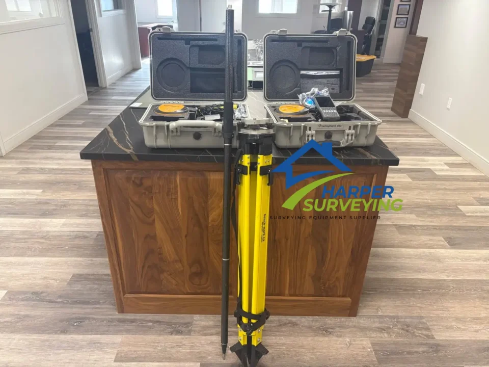
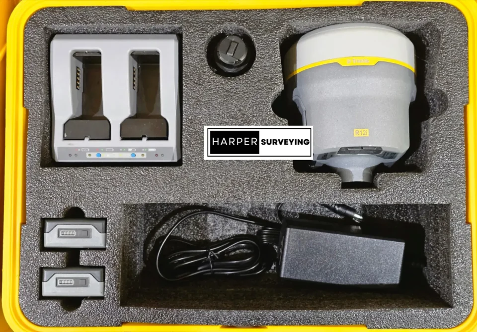
What’s In The Box:
- (1) Spectra SP90M GNSS Receiver With Internal 410-40 MHz UHF Radio
- (1) Antenna 5″ Whip – TNC 410-470MHz Radio
- (1) Bluetooth Antenna
- (1) Li-Ion Battery 7.4V, 3700mAHr
- (1) Dual Li-Ion Battery Charger
- (2) Battery Spacer Inserts for Charger
- (1) Power Supply 100-240VAC
- (1) Cable – 1.5m, DB9(F) Y to 0S/7P/M to Power Jack
- (1) OTG Cable USB A to Mini USB B
- (1) Tape Measure, 3.6m / 12ft
- (1) Transport Bag
- (1) Quick Start Guide