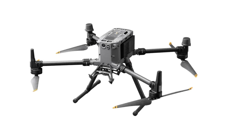
DJI Zenmuse L3 combines LiDAR with a high-resolution RGB mapping camera, delivering real-time 3D data and centimeter-level accuracy. Designed for DJI’s Matrice 400, it streamlines terrain modeling, inspection, and post-processing via DJI Terra.
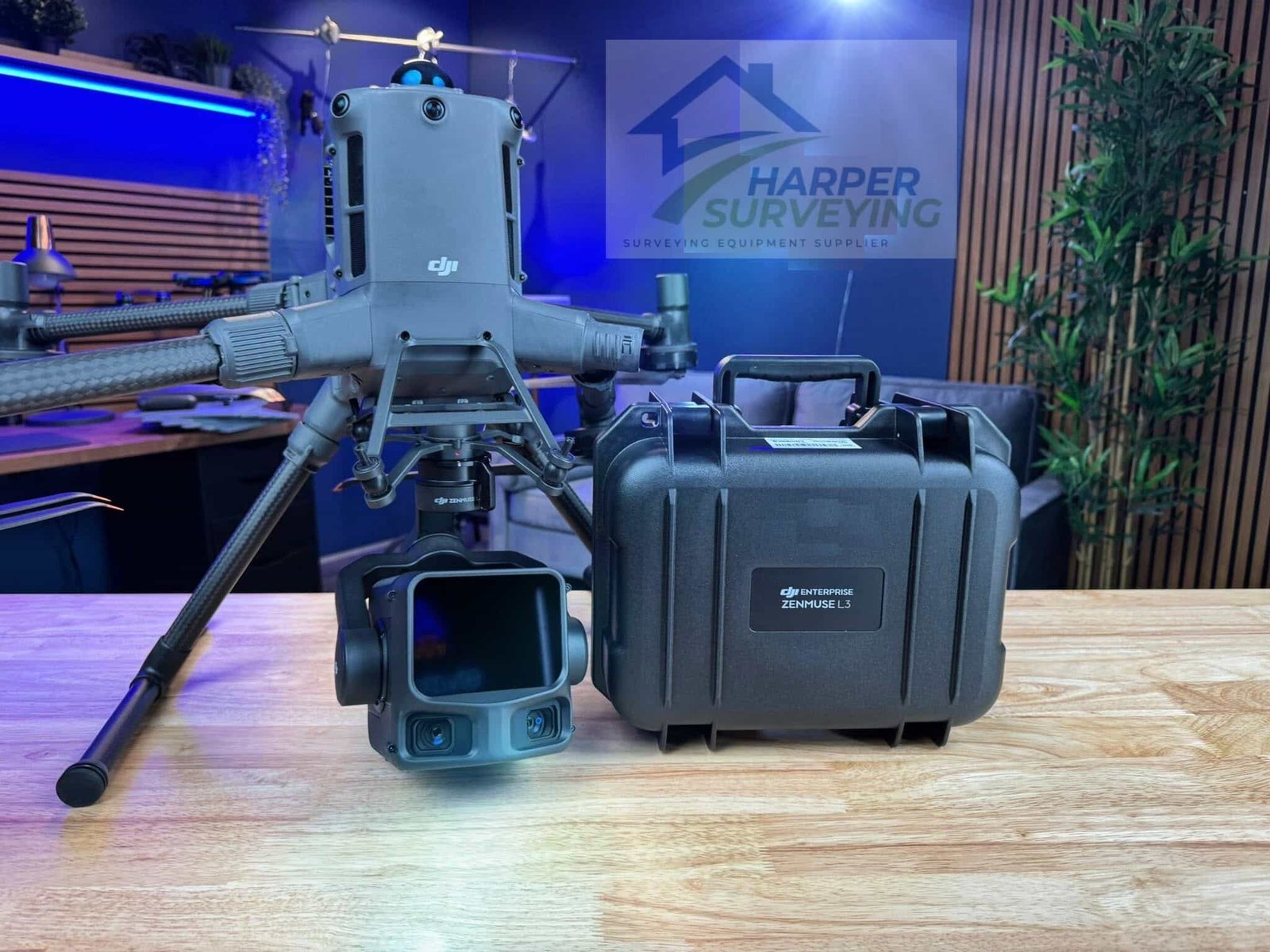
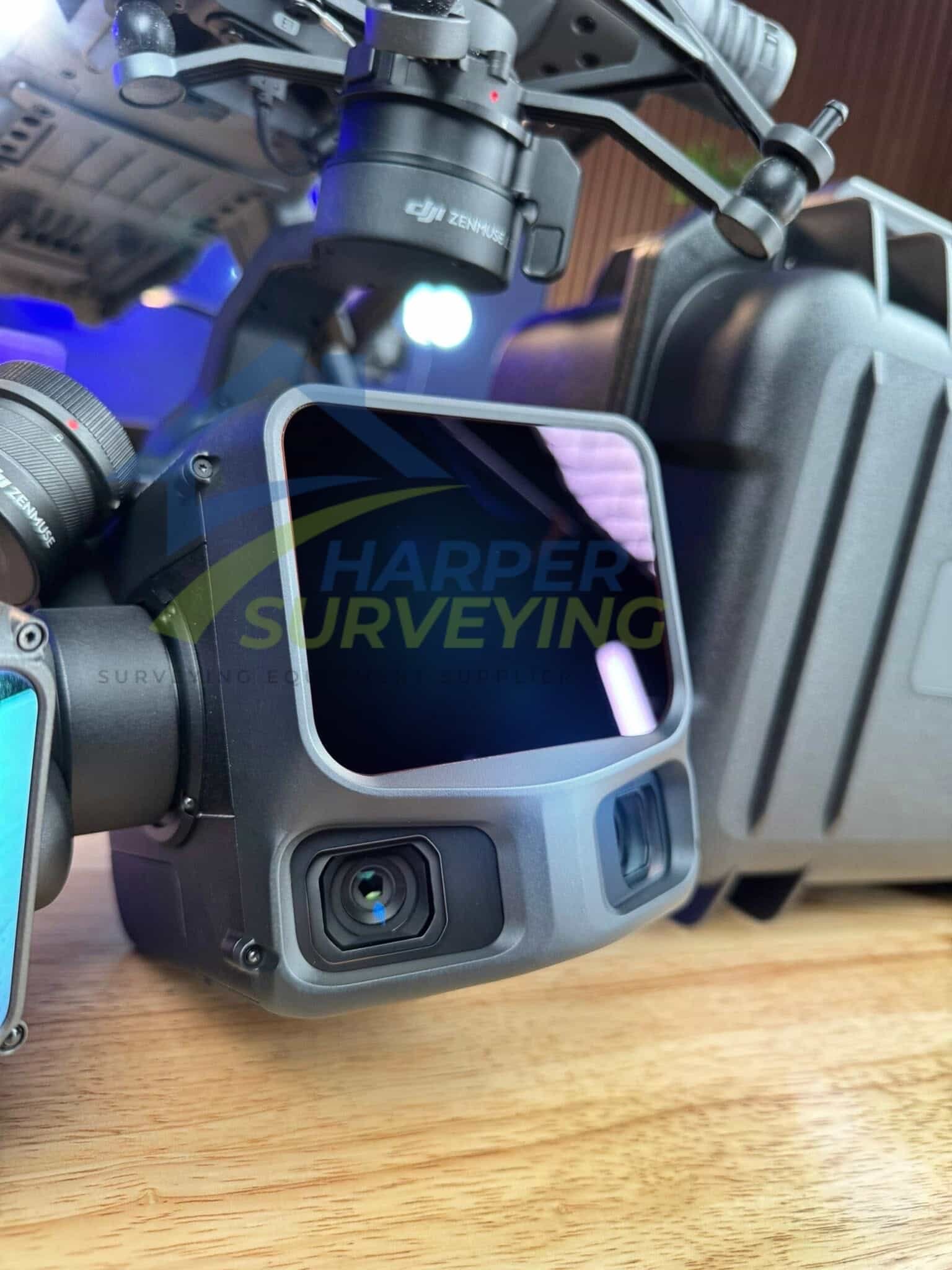
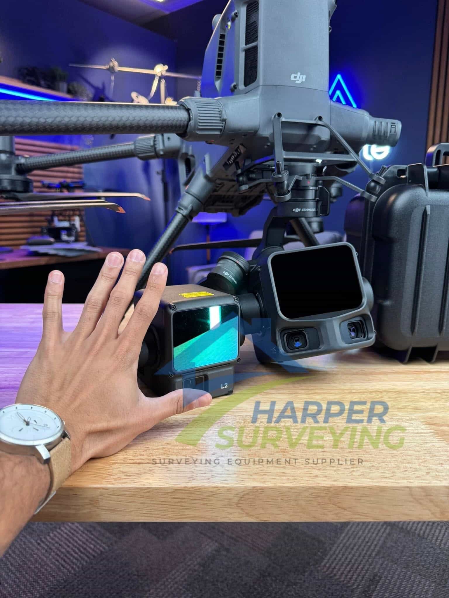
The DJI Zenmuse L3 is DJI’s most advanced aerial LiDAR payload to date, combining a 1535nm long-range LiDAR module, dual 100MP RGB mapping cameras, a highly accurate position and orientation system (POS), and a 3-axis gimbal—all within a compact, fully integrated sensor package.
Purpose-built for demanding geospatial and engineering survey missions, the Zenmuse L3 captures dense, high-accuracy point clouds while simultaneously acquiring photogrammetry-grade imagery over large areas in a single flight.
L3 features a maximum detection range of 950 meters, supports up to 16 returns per pulse, and offers multiple scanning modes, including Linear, Star-Shaped, and Non-Repetitive patterns, to meet a wide range of mission types. Paired with the DJI Matrice 400 platform, Zenmuse L3 can collect up to 100 km² of data per day, transforming long-duration survey projects into efficient, single-day operations.
DJI Zenmuse L3: Long-Range LiDAR and Dual 100 MP Camera Payload for Survey-Grade Mapping
The DJI Zenmuse L3 LiDAR Camera is a flagship long-range LiDAR and imaging payload engineered for precision aerial mapping, topographic modeling, and high-detail inspection.
Equipped with a 1535 nm Class 1 laser and dual 100 MP Micro 4/3 cameras, it delivers up to 950 m range and 2–4 cm accuracy for professional surveying and digital-twin applications.
Built exclusively for the Matrice 400 RTK, the L3 integrates seamlessly into DJI Terra workflows, producing point clouds, orthophotos, and 3D models—all within a single processing environment.
Key Features
- 1535 nm, 100 W Class 1 laser for extended range
- Adjustable point rate: 100 kHz / 350 kHz / 1 MHz / 2 MHz
- Practical measuring range: 300–500 m
- Supports 16 returns for complex terrain modeling
- Highly integrated design with high-precision IMU and dual-camera module
- Durable mechanical shutter rated for 500,000 cycles
- Direct point cloud output with support for Gaussian Splatting visualization
Standout Features
- Long-range LiDAR system: 950 m @ 10% (100 kHz) and 700 m @ 10% (350 kHz).
- High-efficiency mapping: covers up to 10 km² per flight or 100 km² per day
- Survey-grade accuracy: delivers 2–4 cm precision for mapping applications.
- Adjustable point-rate control: 100 kHz – 2 MHz to balance density and coverage.
- Configurable returns: 16 (100 / 350 kHz), 8 (1000 kHz), 4 (2000 kHz).
- Dual 100 MP Micro 4/3 cameras: generate orthophotos and colorized point clouds.
- Real-time point-cloud preview: measure points, lines, and areas in DJI Pilot 2.
- Compact low-power design: 1.6 kg payload draws only 64 W typical power.
- Rugged environmental build: IP54 rated for –20 °C to +50 °C operation.
- Streamlined workflow: integrates directly with DJI Terra and Modify.
- DJI Care Enterprise Plus: 1-Year coverage activated upon first use.
Hardware Performance Redefined

DJI Zenmuse L3 integrates a 1535nm long-range LiDAR sensor, dual 100 MP RGB mapping cameras, a high-precision position and orientation system (POS), and a 3-axis gimbal into a single, compact payload. This streamlined design delivers exceptional accuracy, range, and efficiency, enabling faster data collection and reduced system complexity in the field.
1535nm Long-Range LiDAR
Long Range, Wide Coverage
DJI Zenmuse L3 delivers a detection range of up to 950 meters at 100 kHz pulse rate, even on surfaces with just 10% reflectivity under 100 klx lighting. With adjustable pulse frequencies, it provides flexibility in power output to suit different mission types. Typical flight altitudes of 300-500 meters expand single-flight coverage and increase mapping throughput.
Small Spot, High Energy
The system uses a laser beam with a divergence of only 0.25 mrad (1/e²), producing a spot size approximately one-fifth that of the Zenmuse L2 at equivalent range. This enables reliable detection of small features like cables and thin branches. The higher energy density enhances vegetation penetration, improving ground point density and structure detail in complex terrain.
High Pulse Rate, Multiple Returns
DJI Zenmuse L3 supports pulse rates up to 2 million pulses per second and captures up to 16 returns from each pulse. This level of return flexibility allows operators to tune data density and penetration depth for applications ranging from fine-detail terrain modeling to dense forest canopy analysis.
Scanning Modes
Operators can choose from three scanning patterns tailored to specific use cases:
- Linear: Delivers consistent point cloud distribution, ideal for precise elevation and topographic models.
- Star-Shaped: Offers varied scan angles to balance density and penetration—suited for forests and urban zones.
- Non-Repetitive: Maximizes coverage and structure detail in corridor inspections, such as power lines and towers.
Dual 100MP RGB Mapping Camera System
Dual 100MP RGB Mapping Cameras
DJI Zenmuse L3 features two 100MP RGB cameras, each equipped with a 4/3 CMOS sensor and mechanical shutter. The system supports pixel binning to achieve a 25MP effective resolution, improving light sensitivity and color accuracy even in low-light conditions. This dual-camera design captures high-resolution imagery suitable for photogrammetry and colorizing point clouds in a single flight.
107° Ultra-Wide FOV
With a combined horizontal field of view of 107°, the dual RGB cameras cover a wide area per capture. Even with a LiDAR side overlap of just 20%, operators can collect RGB data for both digital orthophoto maps (DOM) and digital elevation models (DEM) simultaneously, increasing coverage and reducing the number of required flights.
Accuracy Meets Efficiency

DJI Zenmuse L3 improves both point cloud and photogrammetric accuracy while enabling faster workflows. Paired with the DJI Matrice 400, a single flight can cover up to 10 km², enabling high-precision mapping over up to 100 km² per day. This level of efficiency allows teams to complete large-area survey projects with fewer flights and faster turnaround times.
High Accuracy
Proprietary High-Precision System

DJI Zenmuse L3 features an advanced high-precision POS system that delivers post-processed heading accuracy of 0.02° and pitch accuracy of 0.01° (1σ). Its self-developed LiDAR system achieves a ranging repeatability of 5 mm at 150 meters and supports microsecond-level time synchronization. Each unit is calibrated at the factory to ensure consistent, survey-grade results across different environments and mission profiles.
LiDAR Data Accuracy
Vertical accuracy is better than 3 cm at 120 meters, better than 5 cm at 300 meters, and better than 10 cm at 500 meters. This enables support for mapping projects at 1:500, 1:1000, and 1:2000 scales. Compared to previous-generation systems, the L3 produces thinner point clouds, making it better suited for applications requiring precise elevation models or surface reconstruction.
Photogrammetric Accuracy
The dual 100MP RGB-mapping cameras maintain a ground sample distance (GSD) of just 3 cm even at 300 meters’ altitude. Real-time synchronization between the LiDAR and RGB data enables precise mapping without the need for ground control points (GCPs), supporting both rapid deployment and high-resolution deliverables.
Profile Tool
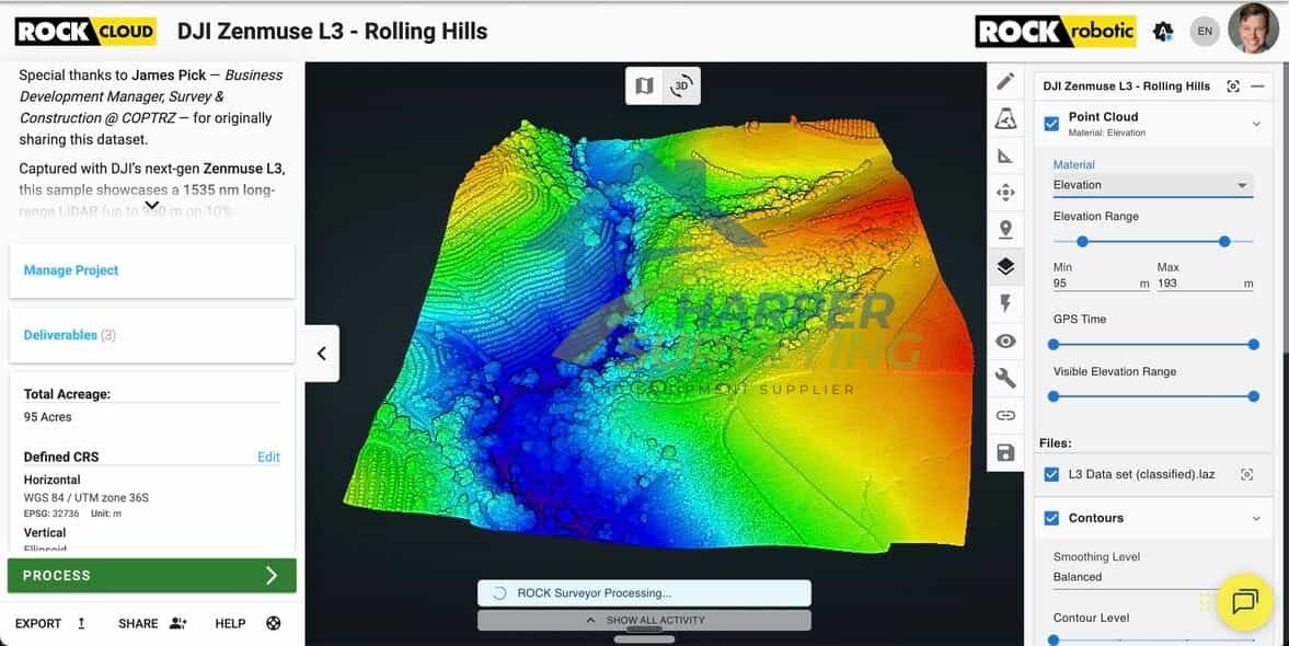
With the Profile tool in DJI Modify, users can select custom cross-sections of point cloud data to analyze elevation changes, structural geometry, and terrain contours. This functionality supports more intuitive interpretation of complex site features.
Comprehensive Output Capabilities
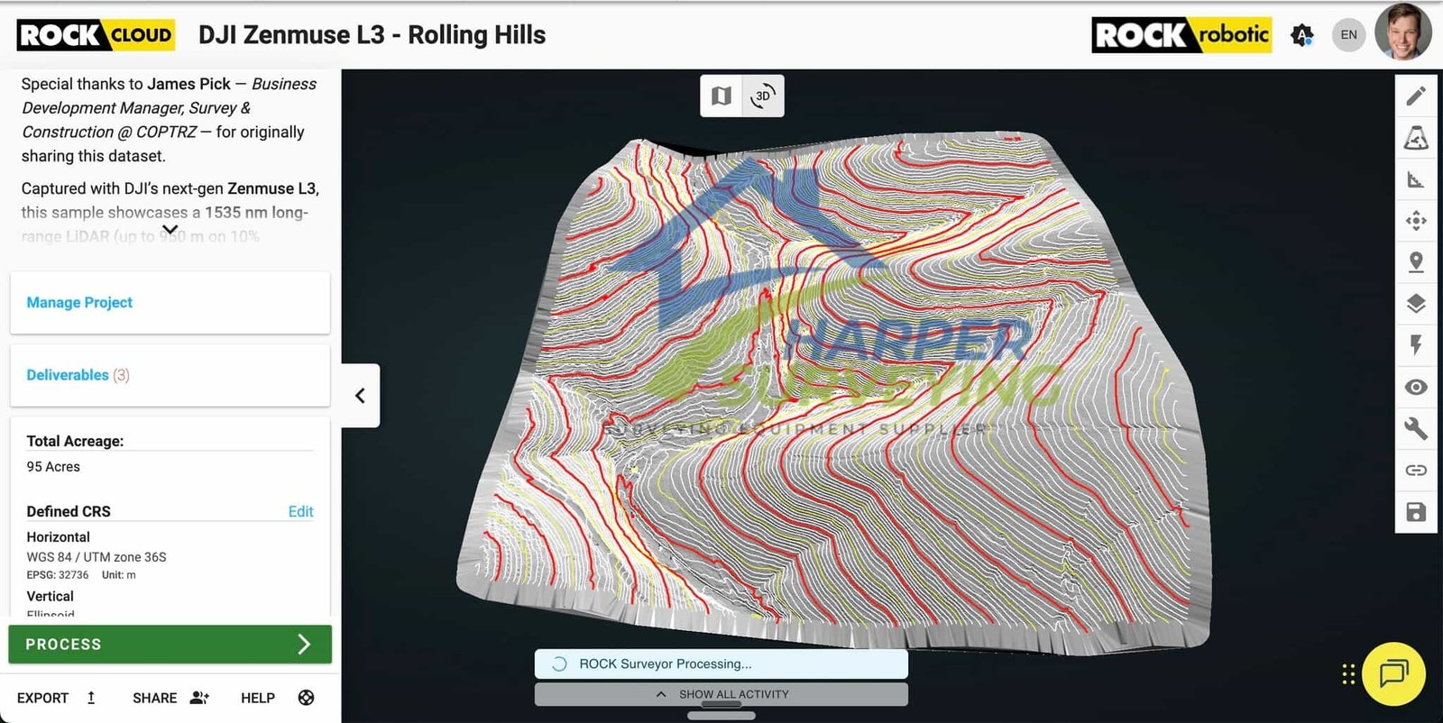
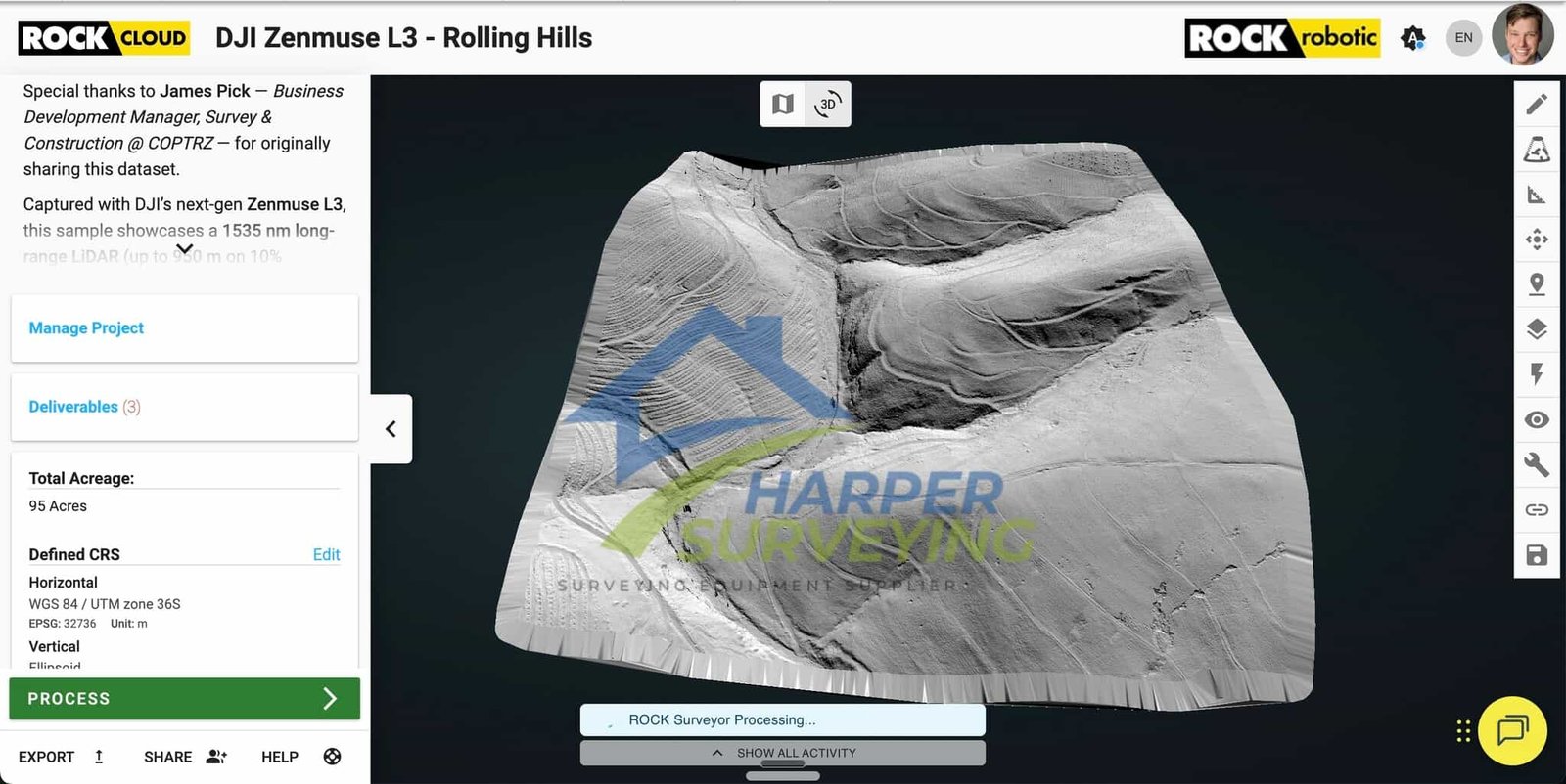
DJI Zenmuse L3 supports a wide range of deliverables when processed with DJI Modify, including semantic point clouds, digital elevation models (DEMs), triangulated irregular networks (TINs), point grids, and contour lines. These outputs are compatible with CAD and GIS workflows and support multi-layer visualization for engineering, planning, and design applications.
Complete Workflow Integration

DJI Zenmuse L3 supports a fully streamlined workflow—from field deployment to data processing and final output—across DJI’s enterprise ecosystem. This integration eliminates the need for third-party platforms or complex file transfers, allowing mapping teams to work faster, more securely, and with greater consistency across diverse mission profiles.
Selection guide
- Choose Zenmuse L2 for standard mapping altitudes, lighter payload power/weight, and flexible aircraft support across Matrice 300/350/400.
- Choose Zenmuse L3 for longer detection range, high-altitude mapping efficiency, explicit wire detection, higher return counts, and higher-resolution RGB capture.
- Choose based on workflow: microSD capture is simpler for smaller teams, while CFexpress capture is optimized for high-volume datasets.
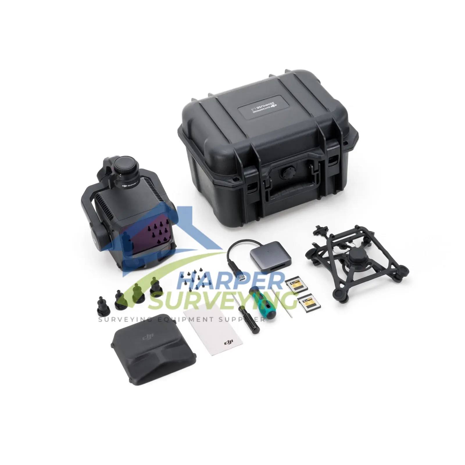
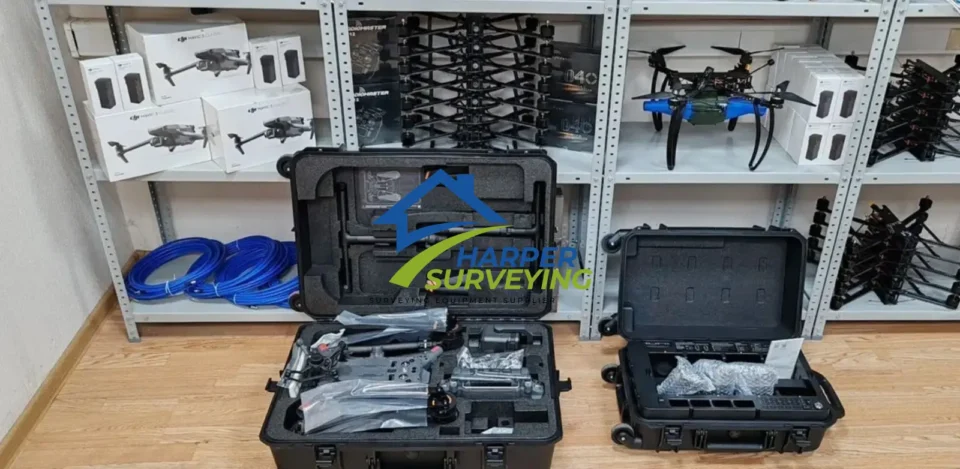
In the box:
- 1× Zenmuse L3 payload
- 1× Zenmuse L3 single-port gimbal mount, including shock-absorbing ball set (L3-compatible only)
- 2× CF-Express Type B memory card (1 TB each)
- 1× CF-Express Type B card reader
- 1× Screw tool set
- 1× Storage box
- 1× Lens cloth
- 1× M400 transport box inner liner (for L3 fit)
Reference
![Autel Robotics Evo II Dual 640T RTK V3 [Including RTK Module]](https://harpersurveying.com/wp-content/uploads/2025/08/Autel-Robotics-EVO-II-7.webp)